Product
One platform for install verification, from jobsite to office.
Argyle puts the BIM model on site at full scale, so field and office work from the same verified picture.
Argyle is an augmented reality platform for construction that overlays coordinated BIM models on the jobsite so teams can verify installs, log spatial observations, and share field data in real time.
Platform
One platform for the jobsite and the office.
Field teams capture on iPad and iPhone. The office works in the Argyle web portal. Both sides see the same projects, models, and observations, as they happen.
In the office
The Argyle web portal
Projects and models
Every project, its models, and who can access them, in one place.
Observations and AR media
Review observations from the field as New or In Progress, with the AR media attached.
QR codes
Manage the site QR codes that open the right project and model in the field.
Users and roles
Invite your team and control who can view, capture, and manage.
Live stream
Join the live AR view from the field and look at the same install from the office.
Project at a glance and CSV export
A summary of what has been captured and what still needs attention, plus CSV export for your own reports.
In the field
Field apps for iPad and iPhone
Model on site in AR
Align the coordinated model to the physical space and walk it at full scale.
Capture observations in place
Pin notes, photos, and AR media to the exact spot, with a status your team can track.
QR codes on site
Scan a QR code to open the right project and model in the field.
Live stream to the office
Share what the device sees so the office can join the call and look at the same install.
Learn more about the iPad and iPhone app.
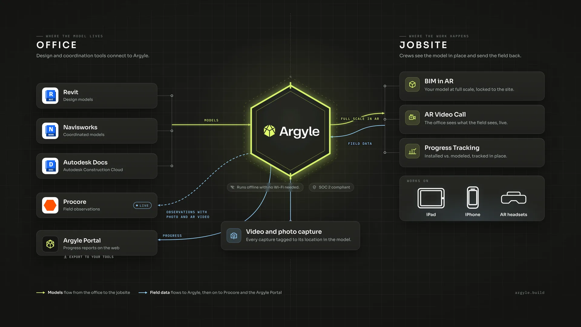
Model sources and integrations
What Argyle is
A spatial operating system for the site.
Sites become structured spatial datasets with shared coordinates. Argyle understands where you are and surfaces the right data in context.
Models
Full BIM geometry in place. Your Revit, Navisworks, or ACC model overlaid exactly where it should be in physical space.
Observations
Field notes, RFIs, and issues. Geo-anchored notes, photos, and markup tied to real positions in the model and field.
Photos and video
Spatially pinned to exact location. Every capture is tied to a coordinate as well as a timestamp. Find it months later by location.
Metadata and geometry
Layers, IDs, and status. BIM properties, phase filters, workset visibility, and element metadata surfaced in the field.
Problem
Field teams need an overlay they can trust.
When the overlay drifts, teams stop trusting it. The tools get shelved, the practice goes untried, and field teams go back to paper.
- Drift increases as you move. The further you walk from the calibration point, the less you can trust what you see.
- Alignment breaks across floors and distances. Alignment is hard to hold across floors.
- Setups are fragile and hard to repeat. Every shift means starting over. Workflows that depend on repeatability don't survive.
The difference
Built to minimize drift across real conditions.
Drop an anchor and go, then move across floors. Argyle is built to hold alignment as you walk the site.
iPad and iPhone
Full spatial workflow on the device your crew already carries.
Across large areas
Built to hold alignment as you move away from the calibration point.
How it works
From model to verified install.
Argyle fits into the workflow your VDC and field teams already run.
Upload your model
Export from Revit or Navisworks, or sync from ACC. Your model arrives with hierarchy, phases, and properties intact.
Align on site
Drop a spatial anchor. The model locks to physical space as you walk the site.
Walk the jobsite
Navigate the AR model in real space. Verify installs, check alignment, inspect clashes in situ.
Verify and capture
Log observations spatially. Drop notes and photos tied to exact coordinates and model elements.
Share instantly
Data flows to the office in real time. No re-entry. No email chains. PMs see field conditions as they happen.
Workflow
Connected to your systems.
Argyle works with the BIM tools your VDC team already uses.
Native
Autodesk ACC, Revit, and Navisworks
Out-of-the-box compatibility with the BIM formats and platforms your VDC team already uses.
By agreement
Custom integrations
Connect additional datasets and systems. An API is available under agreement for organizations with complex existing workflows.
Devices
Run on what your team already uses.
Argyle meets your crew where they are.
iPad and iPhone
The most accessible option on site. Every crew member can participate immediately. See the iOS app.
BIM stuck in the office? Bring it into active construction. Complex BIM models are optimized for field performance.
Verify installs before committing work
See exactly where something should be before a single bolt is turned. Catch conflicts before they become rework.
Coordinate across trades in dense MEP zones
Mechanical, electrical, and plumbing, overlaid in context, in the ceiling, on the wall. No more 2D guessing.
Capture spatially aware photos and video
Every piece of documentation is pinned to an exact location. No more "where was this taken?" conversations.
Share real-time field conditions with the office
What's happening on site is immediately visible to project managers, architects, and owners, with no translation required.
Improve onboarding of junior field staff
New crew members can orient themselves spatially from day one. The model is always there. The site makes sense faster.
From "I think this is right" to verified on site
Intuitive visual verification, so you know that what you've built is correct.
Security
Ready for sensitive project data.
Built for organizations where project data is sensitive and security is non-negotiable.
SOC 2 compliant
Argyle is SOC 2 compliant. Read more about how we protect project data on the security page.
In the field
What VDC teams are saying
“We're using it to expedite layout. I was able to layout several missing embeds with Argyle while on site. Then we sent the field team layout points and they were able to confirm my Argyle layout was in the correct location per the fabricator. Total Station layout points. Big Win.”
Michael Wickersham, VDC
Miller Electric Company
“Once we started getting the PMs and the executives to see the videos and see how quickly we could find things, they were like 'we need to get this everywhere'. This is the first AR technology I've ever been shown that I immediately understood and can immediately see the value in.”
Tyler Simches, VDC
Integrated Project Services
FAQ
Questions about the Argyle platform
What is Argyle?
Argyle is an augmented reality platform for construction that overlays coordinated BIM models on the jobsite so teams can verify installs, log spatial observations, and share field data in real time. It includes a web portal for the office and field apps for iPad and iPhone.
What does the Argyle web portal include?
The portal is where the office manages projects, models, observations, AR media, QR codes, and users. It also includes a live stream of the field view and CSV export for your own reports.
Which devices does Argyle run on?
Argyle field apps run on iPad and iPhone. Crews can start on the iOS devices they already carry.
Which model formats does Argyle support?
Export your model from Revit or Navisworks, or sync it from Autodesk Construction Cloud (ACC). The model arrives with hierarchy, phases, and properties intact.
Is Argyle secure?
Argyle is SOC 2 compliant.
Start a pilot
See this on your project.
Share a few details about your project and team. We'll follow up to talk through scope, devices, and what you want to verify in the field.
Work email only. We use it to follow up about a pilot.